http://www.diploweb.com/The-Greco-Turkish-dispute-over-the.html
Par , le 10 avril 2009
Didier Ortolland is Coordinator of the Geopolitical Atlas of Maritime Spaces ; he writes here in a personal capacity
The evolution of the Law of the Sea, which gives countries new spaces of sovereignty and areas of jurisdiction without specifying their delimitation, is the source of the dispute between Greece and Turkey in the Aegean Sea. This article sets out possible solutions for the delimitation of territorial waters, the continental shelf and exclusive economic zones with reference to the established related jurisprudence and the practice of the states, while taking into consideration the equity and security requirements of both countries.
As part of its strategy of geopolitical synergy, www.diploweb.com is pleased to present this article, which first appeared in Défense nationale et sécurité collective, February 2009, pp. 74-87.
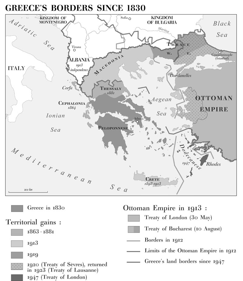
IN THE course of the last 40 years, Greece and Turkey have found themselves on the brink of war because of their basic opposition concerning the exercise of sovereignty on the waters of the Aegean Sea. Historical factors weigh heavily : Turkey lost most of its European territories in the nineteenth and twentieth centuries (see map), while Greece maintained cultural hegemony over the area as well as the shoreline of Anatolia since ancient times : Constantinople fell into the hands of the Ottomans five centuries earlier (1453) but the Greek populations remained until recently on the eastern bank of the Aegean Sea. The Treaty of Lausanne dated 24 July 1923 led to the flight of 1.3 million Greeks from the regions of Smyrna and Eastern Thrace, and of 400,000 Muslims who left Western Thrace to settle in Turkey. There are two opposing historical realities coupled with resentment.
The territorial division resulting from the Treaty of Lausanne [1]and the Treaty of Paris of 10 February 1947 [2]seemed relatively stable ; Greece logically had almost all of the islands of the Aegean Sea, populated by Greeks since ancient times. However, the evolution of international law, following the Second World War, and particularly after 1958, [3] has hampered the status quo.

- Greece’s borders since 1830
The Law of the Sea and the Greco-Turkish dispute
The evolution of the Law of the Sea is at the source of the Greco-Turkish dispute in the Aegean Sea. The exercise of sovereignty of the coastal states on the waters situated beyond their territory has been accepted since the eighteenth century ; this territorial sea was at the time limited to 3 nautical miles (n miles). With technological progress, the states felt the need to enlarge their waters to ensure security and to exploit the marine and subsoil resources. This extension of areas under sovereignty (territorial waters) and under jurisdiction (continental shelf and exclusive economic zone) is the source of many disputes, including those of the Aegean Sea. Due to the difference between states giving greater importance to free navigation and those concerned foremost about their security or the exploitation of marine resources beyond their territory, the 1958 Convention on the Territorial Sea and the Contiguous Zone said nothing about the maximum breadth of the territorial waters. Some countries have meanwhile decided to extend it to 12 n miles ; it has been the case for France since 1971. The exploitation of hydrocarbons of the continental shelf, beyond territorial waters, developed rapidly. The Convention on the Continental Shelf of 29 April 1958 recognized this right. Finally, the concept of exclusive economic zone (EEZ) which allows the exercise of jurisdiction over 200 n miles was to be acknowledged by the United Nations Convention on the Law of the Sea concluded at Montego Bay in December 1982. Many countries did not wait for the signing of the Convention to establish EEZs beforehand ; France did so in 1976. These developments disturbed the relative stability of the Aegean Sea respected since the end of the Second World War and raised a controversy regarding territorial waters and the continental shelf.Territorial waters
Greece has extended its territorial waters to 6 n miles by an Act of September 1936. Greek territorial waters thus cover 43.5 per cent of the Aegean Sea while Turkish territorial waters represent only 7.5 per cent. If the territorial waters of the two countries were brought to 12 n miles, 71.5 per cent of the Aegean Sea would be under Greek sovereignty and 8.7 per cent Turkish. The area of high sea would be reduced from 49 per cent to 19.7 per cent. If the two countries established EEZs, the remaining space (19.7 per cent) would fall entirely under the jurisdiction of Athens. [4] This explains why Turkey has always exerted pressure on its neighbour, claiming that the enlargement of Greek territorial waters to 12 n miles would represent a casus belli. The Turkish Parliament endorsed this stance with a resolution adopted in June 1995, shortly after Greece’s ratification of the Montego Bay Convention. The difficulty arises from the fact that, under the Convention, ‘ships of all States, whether coastal or land-locked, enjoy right of innocent passage’ in the territorial waters of another state. This right involves restrictions for military vessels and submarines (which are required to navigate on the surface) and could be regulated by the coastal state. If the Greek territorial waters were extended to 12 n miles in the Aegean Sea, Turkish warships coming from the Bosporus or from Izmir would be subject to the limitations of the ‘right of innocent passage’ or even to regulations adopted by Athens to link the central Mediterranean Sea.
The continental shelf
In November 1973, the Turkish government allotted fuel research zones to the Turkish State Petroleum Company in the area located between the Greek islands of Lesbos, Skiros, Limnos and west of Samothrace. In July 1974, it further issued new permits extending this zone to the West and claimed a new narrow portion of the continental shelf located between the Greek islands of the Dodecanese and the Cyclades. Greece strongly protested against these two decisions. Turkey nevertheless sent oceanographic vessels to the contested area : the Candarli in May-June 1974, and also the Sismik I, in August 1976, whose mission brought the two countries to the brink of armed conflict. Their positions could then be summarized as follows :
. For Greece, international law, and specially the Convention on the Continental Shelf, gives the islands the right to exercise jurisdiction on their continental shelf and specifies that the continental shelf between two countries must be defined on a median line basis. [5] Thus, each of the islands of the Aegean Sea has its continental shelf, and the frontiers with Turkey should be defined on the basis of the median line.
. For Turkey, the Greek islands do not have rights to exert jurisdiction on the continental shelf, as they are located on the Turkish continental shelf. The ‘special circumstances’ mentioned by the Convention on the Continental Shelf (Art. 6.2) justify in this case the non-application of the median line method.
Noting that the different positions were leading nowhere, Greece submitted the controversy to the International Court of Justice (ICJ) in August 1976 but Turkey refused to recognize the jurisdiction of the Court, which in the end declared itself incompetent. [6] Since then, the maritime issue has remained and has been aggravated by territorial arguments. [7] International law has, however, evolved, affecting the position of the countries and adding to the controversy. The Montego Bay Convention reinforced the position of Greece in specifying that the coastal states could extend the area of their territorial waters to 12 n miles, while strengthening the Turkish position by removing any reference to the median line in the delimitation of the continental shelf. In effect, according to the Convention, the delimitation of the territorial waters as well as the EEZ ‘shall be effected by agreement, on the basis of international law . . . in order to achieve an equitable solution.’ (Arts. 74 and 83) Turkey is one of the rare states that have refused to sign the Convention because it refuses the possibility of extending the width of territorial waters to 12 n miles. The Convention cannot therefore be applied to Turkey, in theory, but jurisprudence tends more and more to consider that its principal provisions belong nevertheless to customary law.
Jurisprudence and maritime spaces
Jurisprudence fills the gaps in the Law of the Sea Convention on the delimitation of maritime spaces. The silence of the Convention on the methods of delimiting maritime spaces has been progressively covered by the jurisprudence of the ICJ, which has established applicable principles ; the Court has thus defined the notions of equidistance/special circumstances for the delimitation of the territorial sea, and of equitable principles/pertinent circumstances for the continental shelf and the EEZ, which involves—to simplify matters—tracing a provisional median line to check if the result is equitable. Considering the many special circumstances presented by the Aegean Sea, one may suppose that the result in this case would not be equitable. Several decisions regarding contentious cases highlight useful guidelines for the delimitation of the maritime spaces. [8]. The decision of February 1969 on the continental shelf of the North Sea underlines the right of each state to benefit from the entire continental shelf which ‘represents the natural extension of its territory under the sea’. It has also specified that there should be a reasonable relation between the extent of the zones belonging to each state and the length of its shoreline (proportionality criterion).
. The decision of June 1977 on the continental shelf of the English Channel and the Channel Islands specified that the principle of the natural extension of territory did not have an absolute value and could be restricted in particular circumstances, which resulted in limiting the maritime space of the Channel Islands to 12 n miles embedded within the French continental shelf.
. The decision of June 1993 regarding the maritime delimitation between Greenland and the Norwegian island of Jan Mayen specified that a substantial disproportion between the length of the coast and the allotted maritime surface justifies a correction of the equidistance method.
The applicable law and jurisprudence developed in recent years may thus determine the main principles in delimiting the maritime space of the Aegean Sea, while taking into consideration the fundamental concerns of the two states (equity, security).
The delimitation of territorial waters
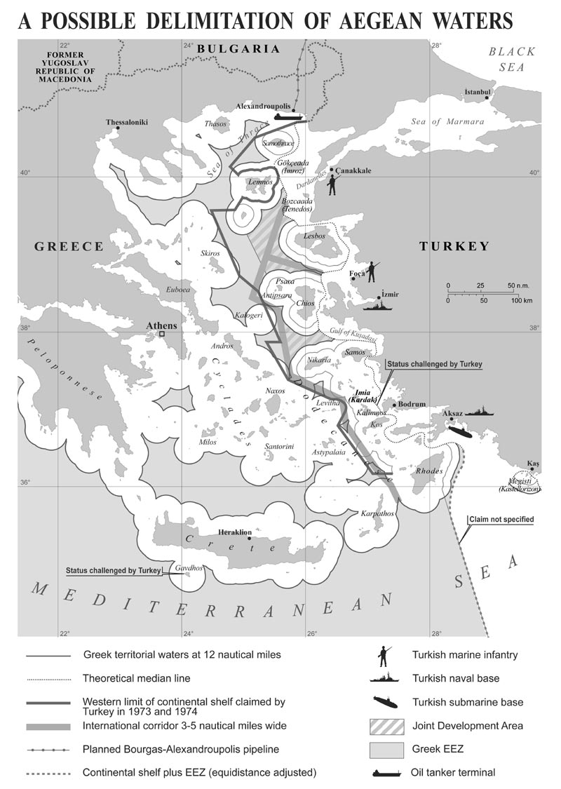
The Montego Bay Convention stipulates that ‘every State has the right to establish the breadth of its territorial sea up to a limit not exceeding 12 n miles. . .’ If international law does not impose a restriction to this rule, some states have meanwhile decided to limit the breadth of their territorial waters to allow a high sea passage between their territorial waters : Japan has voluntarily limited its territorial sea to 3 n miles to avoid territorializing its straits ; the same goes for Estonia and Finland to allow the Russian fleet access to St Petersburg within international waters without having to transit through territorial waters of its neighbours, [9] thus avoiding the regime of ‘innocent passage’. Given a territorial sea limited to 6 n miles, Turkey actually has access to the Turkish straits from the Mediterranean through international waters ; the port of Izmir is likewise accessible without passing through Greek waters. With the extension of the territorial waters to 12 n miles, the territorial waters of the Cyclades and the Dodecanese would be connected, and Turkey would be obliged to pass through Greek waters to reach Istanbul. However, a narrow zone of high seas remains between Chios and Lesbos to reach Izmir.

- A possible delemitation of Aegean waters
Delimitation of the continental shelf
This begins where the territorial waters end, so its extent is based on the breadth of the territorial waters, whether this is 3, 6 or 12 n miles. The Turkish claims (made in 1973 and 1974) begin beyond 6 n miles of the territorial waters of Greece, but since that date international law (Montego Bay Convention) accepts a maximal breadth of 12 n miles without restriction. There are four zones, with different characteristics :
. North of the Aegean Sea : there is an area of high sea beyond 12 n miles measured from the islands of Limnos, Hagios Eustratos, Lesbos, Scyros and Psara. Turkey could claim the entire zone on the basis of the decision of June 1977 (the Channel Islands ‘landlocked’ within the French continental shelf) but Greece could assert that the circumstances are different, since the space is much more limited than in the Channel or the Bay of Granville. The creation of a Joint Development Area [13]could partly satisfy the claims of both parties, determination of the sharing of benefits being the most delicate aspect. [14] Jurisdiction on the continental shelf may be distinct from jurisdiction on the water column (EEZ).
. Central Zone (off the Gulf of Kusadasi) : the proposals for the Northern Zone could apply to the area beyond 12 n miles of each country (creation of a Joint Development Area–see map).
. Southern Zone (between the Cyclades and Dodecanese) : Turkey claims a narrow space starting at 6 n miles from the Cyclades and Dodecanese. The implementation of 12 n miles in this area would leave small pockets of non-exploitable high seas that the principle of equity seems to allot to Greece, the total freedom of navigation for warships being guaranteed in this zone by the creation of an international corridor 3 to 5 n miles wide.
. Area between Rhodes and Megisti : the right of these two islands to territorial waters of 12 n miles cannot be questioned, the maritime space being large enough. The assignment of jurisdiction on the continental shelf and the water column (EEZ) is, however, debatable for Megisti because of the disproportional length of the coastline. [15]This disproportion is less obvious in the case of Rhodes but, due to its location, the full application of the median line for the delimitation of the continental shelf and of the EEZ could be unfair for Turkey and could justify a limited application for Rhodes.
The exclusive economic zone
Greece could freely extend its EEZ in all other areas of the Aegean Sea situated beyond 12 n miles. One may also consider separating the exercise of jurisdiction on the continental shelf from that of the EEZ. The jurisprudence on the ‘natural extension of the territory under the sea’ being applicable only to the continental shelf, Greece might claim jurisdiction on the water column above the Joint Development Areas. However, the delimitation in the Mediterranean (south-east of Rhodes) should follow that of the continental shelf. [16] The international corridor could be given an international status but some competences such as anti-pollution control of commercial ships could be given either to Greece, since this corridor touches on its 12 n miles, or to both countries, or to another entity to be determined.
The Contiguous Zone
A coastal state may carry out checks to ‘prevent infringements of its customs, fiscal, immigration or sanitary laws and regulations within its territory or territorial sea’ in an area of 24 n miles measured from its baselines, that is to say up to 12 n miles outside the external limit of its territorial waters. In the Aegean Sea the two states could exercise this right within the limits fixed above, with the exception of the Joint Development Areas and the corridor.
In 1993 the European Council determined the so-called ‘Copenhagen criteria’, making it possible to evaluate Turkey’s progress in preparation for membership. These criteria included in particular ‘its determination to solve eventual border controversy in conformity with the principle of peaceful settlement of disputes as stipulated in the United Nations Charter, including, if applicable, the recognition of the authority of the International Court of Justice.’ The framework of negotiations, determined by the Intergovernmental Conference of 3 October 2005, opened following the decision to begin negotiations in December 2004, confirms these criteria. It is also specified that during the period prior to possible membership, Turkey shall progressively align its positions with those of the EU in international organizations, which logically implies its adherence to the Montego Bay Convention.
This is a difficult element in the negotiations of which we cannot foresee the outcome. Turkey’s membership of the EU would imply a radical change in its conceptions with regard the Law of the Sea and its recognition of the authority of the International Court of Justice. The jurisprudence of the Court is not necessarily against the positions of Ankara, particularly on the continental shelf, but Turkey should drop its claims regarding the breadth of territorial waters. Another solution would involve voluntary arrangements of this rule in the context of a bilateral agreement or an ad hoc arbitration after determination of mutually agreed parameters which might take into account the suggestions made in this article.
Copyright February 2009-Ortolland/Défense nationale et sécurité collective.
Défense nationale et sécurité collective is a publication whose purpose is to tackle all—national and international—political, economic, social and scientific issues by considering them from the viewpoint of defence. This specific aspect enabled it to outlive WW II and later on all the crises, hardships and regime changes that followed. Its readers in France all still share a common interest in defence and security, despite any differences in opinion, origins or political sensitivity. See
[1]
The Treaty of Lausanne of 24 July 1923 questioned the Treaty of Sèvres
of 10 August 1920 which had amputated the former Ottoman Empire of its
Arab provinces, Anatolian Armenia and Eastern Thrace and the region of
Smyrna (Izmir). After Lausanne, the Arab regions of the Middle East
remained under the mandate of France and the United Kingdom, but Turkey
received the region of Smyrna and Eastern Thrace.
[2] The Dodecanese islands (Rhodes and neighbouring islands) were ceded by Turkey to Italy by the Treaty of London in May 1913. The Treaty of Paris of 10 February 1947 placed the islands under the sovereignty of Athens.
[3] Adoption of the Convention on the Continental Shelf and the Convention on the Territorial Sea and the Contiguous Zone.
[4] The issue on the size of territorial waters has consequences on the airspace, which in general covers the territorial waters. Athens considers that its airspace measures 10 n miles wide around its territory but Ankara only recognizes 6 n miles. A number of incidents have taken place during control operations of the airspace. Two Greek and Turkish fighter aircraft collided in May 2006.
[5] Article 6.2 of the Convention on the Continental Shelf dated 29 April 1958.
[6] Decision of 19 December 1978 : the International Court of Justice declared itself incompetent considering reservations of Greece on the jurisdiction of the International Permanent Court of Justice (which had preceded the ICJ) for the ‘issues related to the territorial status of Greece’.
[7] Turkey claims in effect that Greece can exercise sovereignty only on the islands that have been nominally ceded by the Treaties and questions the sovereignty of Athens on the islet of Imia/Kardak and on the island of Gavdos. This claim was formulated only in 1995.
[8] See in particular Didier Ortolland and Jean-Pierre Pirat, Atlas Géopolitique des espaces maritimes (Courbevoie : Technip, 2008).
[9] It is also the case of Sweden and Denmark for the Danish straits and of Chile for the strait of Le Maire.
[10] The trade of hydrocarbon raises the risk to the environment : importance of the transit via Bosporus (70 million tons per year) and the forthcoming opening of the Bourgas-Alexandroupolis pipeline, which will allow the transport of 35 million tons more starting in 2009 and 50 million tons thereafter.
[11] It is worth noting that Turkey,is not against the principle of a 12 n miles width, as it applies it in the Mediterranean Sea, off Cyprus.
[12] Montego Bay Convention, Art. 15.
[13] Turkey had suggested recourse to this type of arrangement in the 1970s.
[14] There is no rule in this matter ; many agreements provide for an equal, others an unequal, sharing of revenues.
[15] The surface area of Megisti is only 12 sq. km and the island has 430 inhabitants ; the ratio of the length of the coastline is favourable to Turkey.
[16] Turkey, which protested in March 2004 against the negotiation of an agreement on the maritime delimitation between Egypt and Cyprus, seems to claim an area reaching beyond the equidistant in the area.
No comments:
Post a Comment